Toronto’s Street Names And The Stories Behind Them
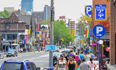
Toronto’s street signs form a scattered biography of the city. Some commemorate politicians, merchants and military figures; others preserve Indigenous language, describe the land or point to a long-forgotten farm. Reading them closely reveals how Toronto grew from a colonial settlement into a dense, multicultural metropolis.
For Australian visitors, the experience may feel familiar in one respect: names change as suburbs merge into one another, and a major road can pass through several distinct local identities. Yet Toronto’s grid, ravines and historic concession roads create a street pattern unlike Melbourne’s tram corridors, Sydney’s winding lanes or Brisbane’s suburban crescents.
A name on a map is also a statement about public memory. It can celebrate a person, preserve a political era or expose who was left out of the official record. Current debates around colonial figures and Indigenous recognition have made ordinary journeys on the TTC part of a much larger civic conversation.
The most interesting names are often attached to everyday places: a bus stop near a bakery, a side street beside a school or a road leading towards a neighbourhood market. For visitors who enjoy walking, street photography and local history, Toronto’s address book offers a useful way to explore the city.
| Street or Road | Name Association | What It Reveals |
|---|---|---|
| Yonge Street | Sir George Yonge | Colonial administration and early surveying |
| Bloor Street | Joseph Bloor | Breweries, property and nineteenth-century development |
| Jarvis Street | The Jarvis family | Elite colonial influence and contested histories |
| Dundas Street | Henry Dundas | The modern reassessment of imperial figures |
| Spadina Road | Anishinaabemowin-derived name | Indigenous geography beneath the urban grid |
Reading Toronto Through Street Signs
Yonge Street is often described as one of the world’s longest streets, although that claim depends on where its northern extensions are counted. Within Toronto, it is a commercial spine running from the lake through the central business district and into North York. Its name honours Sir George Yonge, a British politician and administrator, rather than a local resident.
Spadina offers a different kind of clue. The name is generally linked to an Anishinaabemowin term referring to a hill or elevated place, reflecting the prominent ridge that shaped the route. Exploring the city through a Toronto street guide helps place these names alongside cafés, galleries, parks and neighbourhood businesses rather than treating them as isolated historical facts.
Colonial Foundations And Early Officials
Several central roads carry the names of British officials or members of influential settler families. Jarvis Street recalls the Jarvis family, whose members held important positions in the colonial administration. Bathurst Street takes its name from Henry Bathurst, a British government figure, while Wellington Street references the Duke of Wellington.
King Street and Queen Street likewise carry royal associations. Their names belong to a period when Toronto, then York, was being organised according to British imperial conventions. The broad avenues and regular blocks were practical for surveying, transport and land division, but they also made colonial authority visible in daily life.
Dundas Street And The Politics Of Memory
Dundas Street became one of Toronto’s clearest examples of a name under review. It commemorated Henry Dundas, a British politician associated with delaying abolition legislation. That connection prompted public discussion about whether a street name can be separated from the policies and systems represented by the person it honours.
The debate also illustrates how renaming works in a large city. A change affects addresses, maps, businesses, delivery services and residents, so historical reassessment must be balanced with practical administration. Australians may recognise a similar tension in debates over colonial names and dual naming, particularly where Traditional Owner names are restored alongside or instead of later labels.
Indigenous Geography Beneath The Grid
Toronto’s street network sits on land with deep Wendat, Haudenosaunee and Mississaugas of the Credit histories. The city’s name itself is associated with Indigenous language, while routes such as Spadina retain traces of older geographic descriptions. These references are valuable, though they should not be mistaken for a complete representation of Indigenous presence.
Modern Toronto still has work to do in making Indigenous history more visible in public space. In Victoria, place naming operates under the Geographic Place Names Act 1998 and often intersects with Traditional Owner recognition; Toronto’s process is shaped by different laws and institutions. The comparison is useful for Australian readers because it shows that naming is both cultural practice and government administration.
Women, Workers And Missing Stories
Toronto’s major roads still lean heavily towards male political, military and business figures. Women appear in the city’s civic memory through schools, parks, community buildings and smaller streets, but they are less prominent in the headline addresses that visitors learn first. That imbalance reflects who held property, office and influence when many names were assigned.
The same pattern affects working-class communities and Black Torontonians. Neighbourhoods such as Little Jamaica preserve powerful cultural histories through shops, music, food and festivals, even when the main road names do not commemorate those communities. A late-night walk to Toronto’s late-night bakeries can therefore reveal a more current and diverse city than the street signs alone suggest.
Parks, Roads And Neighbourhood Memory
Not every name honours an individual. Some describe landscape, transport or land ownership, while others come from farms and villages absorbed by urban growth. Roads near ravines often preserve older routes that existed before Toronto’s modern suburbs, and a familiar avenue can shift character several times within a few kilometres.
This is especially clear in North Toronto, where residential streets, ravines and green spaces interrupt the expected urban rhythm. A visit to underused North Toronto parks shows how street names connect with the physical landscape: a sign may point towards a picnic area, a former creek valley or a pocket of woodland that survived development.
How To Explore The City’s Address Book
The best way to investigate Toronto’s street names is to pair a short walk with a map, a local archive and the neighbourhood itself. Start at a major intersection, note nearby lanes and public spaces, then look for changes in street width, building age and commercial life. Toronto’s Saturday markets and café culture make this easy to do at a relaxed pace, much as visitors might combine a tram ride with a market stop in Melbourne.
For Australians, remember that Toronto’s transit system uses the TTC and PRESTO rather than Myki, Opal or go cards, and that Canadian addresses use postal codes rather than Australian postcodes. Choose one route—such as Yonge Street between Bloor and the lake—then record the names, associations and present-day communities encountered along the way. Begin with that walk and write down the first five street signs you pass.